The Global Navigation Satellite System: Navigating the World with Precision
In today’s interconnected world, accurate navigation has become an essential part of our daily lives. Whether we are driving to a new destination, hiking in the wilderness, or tracking shipments across the globe, having reliable location information is crucial. This is where the Global Navigation Satellite System (GNSS) comes into play.
The GNSS is a constellation of satellites that orbit the Earth and transmit signals to receivers on the ground. By triangulating signals from multiple satellites, these receivers can determine their precise location anywhere on the planet. The most well-known GNSS system is the Global Positioning System (GPS), developed by the United States government.
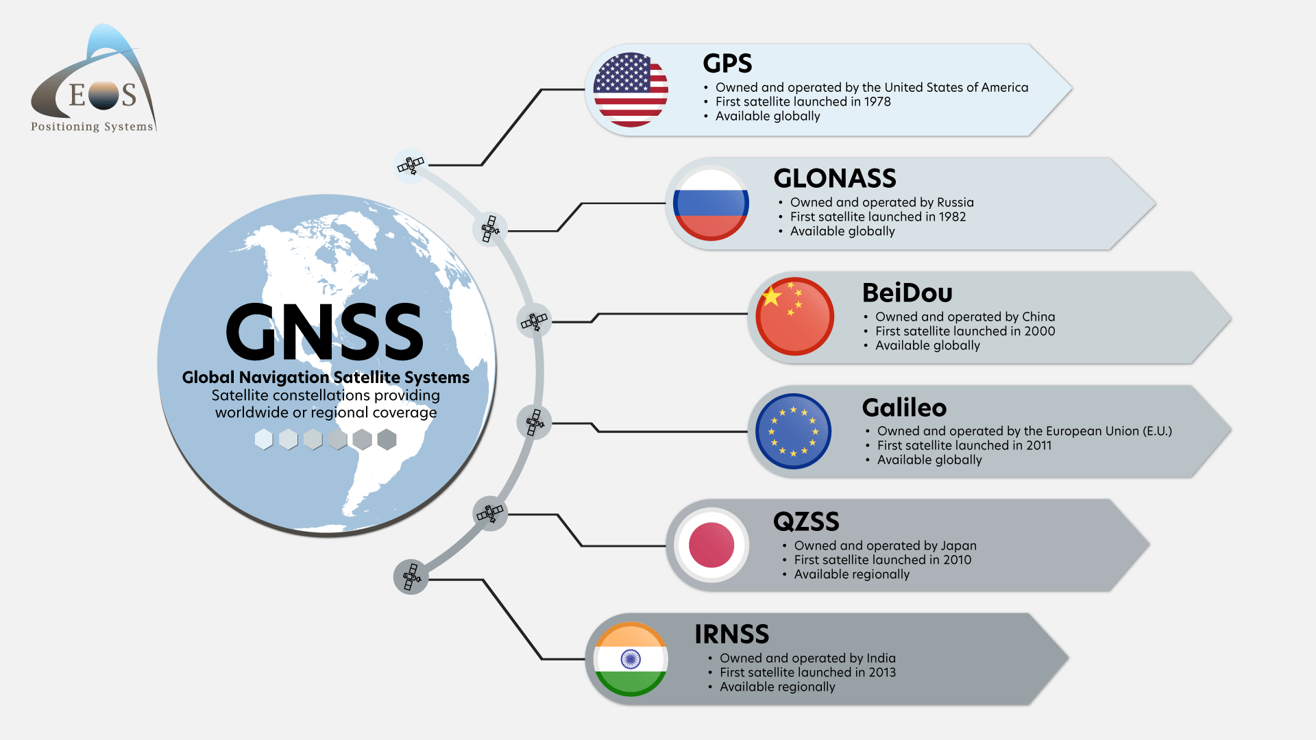
However, GPS is not the only player in town. Other countries and regions have also developed their own satellite navigation systems to enhance global coverage and provide redundancy in case of system failures. These include Russia’s GLONASS, Europe’s Galileo, China’s BeiDou, and India’s NavIC.
One of the key advantages of GNSS is its ability to provide accurate positioning data in real-time. This has revolutionized industries such as transportation, agriculture, surveying, and emergency services. For example, autonomous vehicles rely on GNSS for precise navigation and obstacle avoidance, while farmers use it to optimize crop yields through precision agriculture techniques.
Despite its many benefits, GNSS does have limitations. Signals from satellites can be blocked or weakened by tall buildings, dense foliage, or atmospheric conditions. This can lead to inaccuracies in positioning data known as “multipath errors.” To mitigate this issue, researchers are exploring new technologies such as augmentation systems and ground-based reference stations.
As we look towards the future, the role of GNSS will only continue to grow. With advancements in technology and ongoing improvements to existing systems, we can expect even greater accuracy and reliability in global navigation. Whether you’re planning your next road trip or guiding a spacecraft through outer space, GNSS will be there to help you reach your destination with precision.
Maximize Your GNSS Accuracy: 7 Essential Tips for Reliable Navigation
- Ensure your device has a clear line of sight to multiple satellites for accurate positioning.
- Understand the limitations of GNSS in dense urban areas with tall buildings that can block signals.
- Regularly update your device’s software to improve GNSS performance and accuracy.
- Learn how to interpret different types of GNSS signals (e.g., GPS, GLONASS, Galileo) for better coverage.
- Use GNSS in conjunction with other navigation methods for redundancy and improved reliability.
- Be aware of potential signal interference from sources like electronic devices or atmospheric conditions.
- Consider using an external antenna or booster for enhanced GNSS reception in challenging environments.
Ensure your device has a clear line of sight to multiple satellites for accurate positioning.
To ensure accurate positioning using the Global Navigation Satellite System, it is crucial to ensure that your device has a clear line of sight to multiple satellites. By having a direct line of communication with several satellites in the constellation, your device can triangulate signals more effectively, leading to more precise location information. Obstructions such as tall buildings, dense foliage, or adverse weather conditions can hinder the reception of satellite signals and result in inaccuracies. Therefore, positioning your device in an open area with an unobstructed view of the sky will help optimize the performance of your GNSS receiver and enhance the accuracy of your navigation experience.
Understand the limitations of GNSS in dense urban areas with tall buildings that can block signals.
It is important to understand the limitations of the Global Navigation Satellite System (GNSS) in dense urban areas with tall buildings that can block signals. In such environments, satellite signals may be obstructed or weakened, leading to potential inaccuracies in location data. This phenomenon, known as multipath errors, can impact the reliability of navigation systems relying on GNSS technology. To mitigate these challenges, users should be aware of potential signal disruptions and consider alternative positioning methods when navigating through densely populated urban landscapes.
Regularly update your device’s software to improve GNSS performance and accuracy.
To enhance the performance and accuracy of your Global Navigation Satellite System (GNSS), it is essential to regularly update your device’s software. Software updates often include improvements to the GNSS algorithms, satellite data, and signal processing capabilities, ensuring that your device can provide more precise location information. By staying up-to-date with the latest software releases, you can optimize your GNSS experience and rely on accurate navigation guidance for all your travels.
Learn how to interpret different types of GNSS signals (e.g., GPS, GLONASS, Galileo) for better coverage.
To enhance your navigation capabilities, it is essential to learn how to interpret the various types of GNSS signals, such as GPS, GLONASS, and Galileo. By understanding the differences between these signals and how they work together, you can achieve better coverage and more reliable positioning data. Each GNSS system offers unique advantages and may perform better in certain environments or conditions. By leveraging the strengths of multiple systems simultaneously, you can improve accuracy and ensure a more robust navigation experience across diverse settings.
Use GNSS in conjunction with other navigation methods for redundancy and improved reliability.
By utilizing the Global Navigation Satellite System (GNSS) in conjunction with other navigation methods, such as inertial navigation systems or ground-based reference points, users can enhance redundancy and improve overall reliability. This multi-faceted approach to navigation ensures that even in challenging environments where GNSS signals may be obstructed or degraded, alternative methods can supplement and validate location data. By combining different navigation techniques, individuals and industries can achieve greater accuracy and assurance in their positioning information, ultimately leading to more reliable and efficient navigation experiences.
Be aware of potential signal interference from sources like electronic devices or atmospheric conditions.
When utilizing the Global Navigation Satellite System, it is crucial to remain vigilant of potential signal interference that may arise from various sources, including electronic devices and atmospheric conditions. Electronic gadgets emitting radio frequencies can disrupt the reception of satellite signals, leading to inaccuracies in location data. Additionally, atmospheric conditions such as severe weather or solar activity can also impact signal strength and reliability. By staying mindful of these potential interferences, users can ensure more accurate and reliable navigation outcomes when relying on GNSS technology.
Consider using an external antenna or booster for enhanced GNSS reception in challenging environments.
When navigating in challenging environments where GNSS signals may be obstructed or weakened, it is advisable to consider using an external antenna or booster to enhance reception. By incorporating these additional tools, you can improve the reliability and accuracy of your positioning data, ensuring a smoother and more precise navigation experience. Whether you are trekking through dense forests, driving in urban canyons, or operating in remote areas, investing in an external antenna or booster can make a significant difference in maintaining strong GNSS connectivity.