Aircraft Navigation Systems: How They Guide Modern Flight
An aircraft navigation system helps pilots determine where an airplane is, where it is headed, and how to reach its destination safely. Modern aircraft combine satellite positioning, onboard sensors, radio signals, digital charts, and flight-planning computers to provide a reliable picture of the aircraft’s position and route.
What an Aircraft Navigation System Does
Navigation is more than following a line from one airport to another. Pilots and aircraft systems must account for position, direction, speed, altitude, weather, terrain, airspace restrictions, and instructions from air traffic control. Navigation equipment helps crews plan and monitor a route while supporting safe operations during takeoff, en route flight, approach, and landing.
Many aircraft use a flight management system (FMS) to organize navigation information. The FMS can store a flight plan, calculate routes, and exchange data with other onboard equipment. Pilots remain responsible for monitoring the system, confirming information, and following applicable procedures.
Key Navigation Technologies
Global Navigation Satellite Systems
Global Navigation Satellite Systems (GNSS), including GPS, use signals from satellites to help determine an aircraft’s position. Depending on the aircraft and equipment, satellite navigation can support route guidance and certain instrument procedures. GNSS performance may be affected by signal obstruction, interference, or equipment limitations, so aircraft typically use other sources of information as well.
Inertial Navigation Systems
An inertial navigation system (INS) estimates an aircraft’s movement using onboard sensors that measure changes in acceleration and rotation. It does not depend on receiving signals from satellites or ground stations. Because small measurement errors can accumulate over time, an inertial system may be updated using GNSS or other navigation references.
Ground-Based Radio Navigation
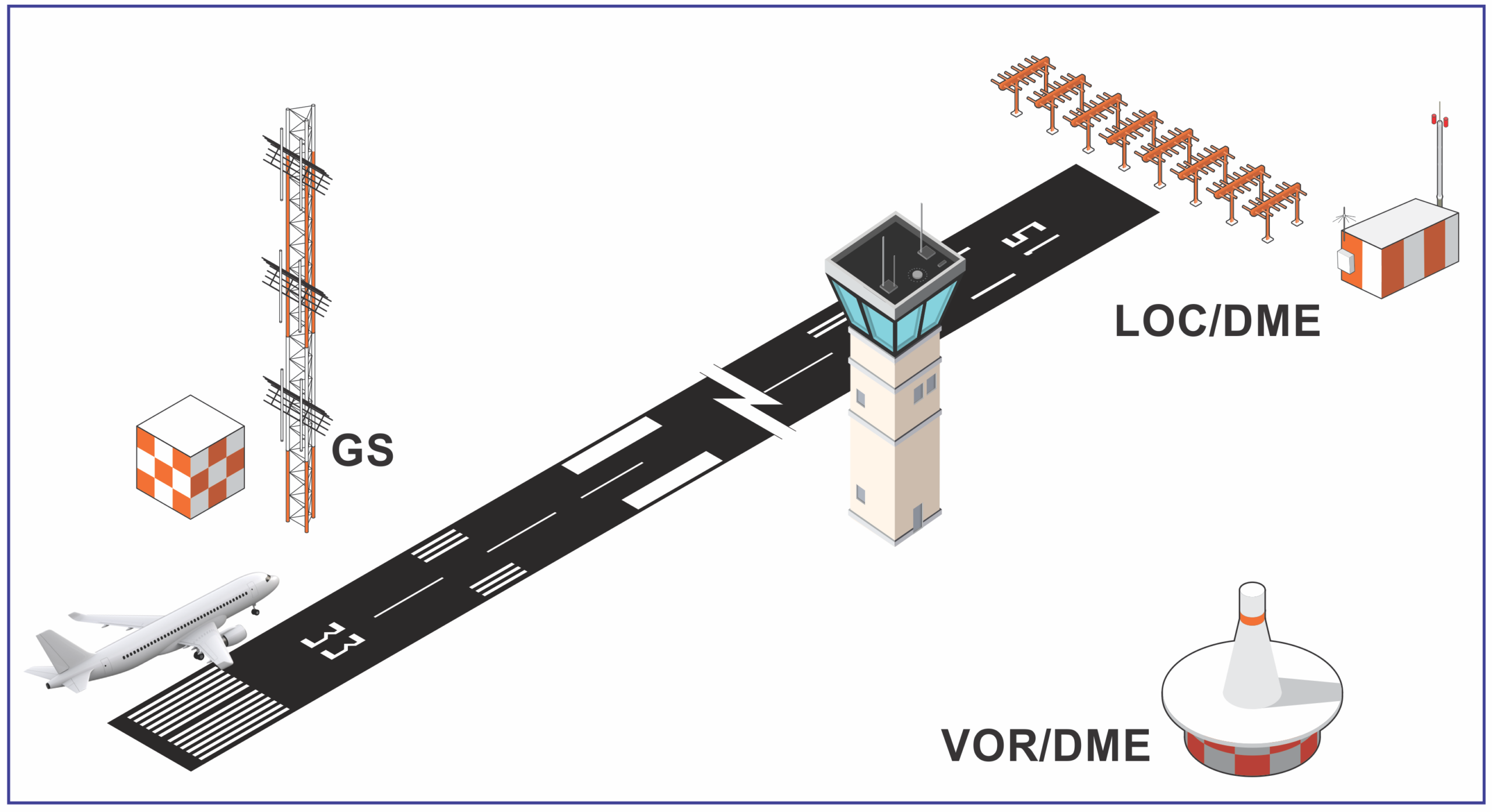
Ground stations provide navigation signals that aircraft can use to determine direction or position. Examples include VHF omnidirectional range (VOR) and distance measuring equipment (DME). Instrument landing systems (ILS) provide guidance for certain approaches to a runway. These systems remain important, although their availability and use vary by location and aircraft.
Air Data and Heading Sensors
Navigation also relies on information about the aircraft’s motion and orientation. Air data instruments provide measurements such as airspeed and altitude, while heading and attitude sensors help show the aircraft’s direction and position in space. These inputs help pilots interpret navigation guidance and manage the aircraft’s flight path.
How the Flight Management System Combines Information
The FMS can combine information from several navigation sources to estimate the aircraft’s position and track its progress along a programmed route. A typical flight plan may include waypoints, airways, altitude restrictions, and procedures for departure and arrival. The system can also calculate estimated times and fuel use based on the data entered and the aircraft’s performance.
Automation can reduce routine workload, but it does not replace pilot judgment. Flight crews verify the route, monitor system messages, compare information with other instruments, and respond when conditions change. The precise features and procedures depend on the aircraft, installed equipment, and operator requirements.
Redundancy and Safety
Aircraft navigation is designed with safety in mind. Depending on the aircraft, multiple sensors and navigation sources may be available so that crews can compare information or use an alternative if a system becomes unavailable. Pilots are trained to recognize discrepancies, follow checklists, and use approved backup procedures.
Navigation equipment is only one part of aviation safety. Accurate flight planning, maintenance, pilot training, air traffic services, and clear communication all contribute to safe operations. Crews must also follow regulations and the procedures published for the aircraft and route.
How Aircraft Navigation Is Changing
Navigation technology continues to evolve. Satellite-based procedures can provide flexible routing and approaches, while digital systems make it easier to share flight and navigation information. At the same time, aviation authorities and operators continue to plan for situations such as satellite signal disruption and maintain procedures that do not rely on a single source.
Conclusion
Modern aircraft navigation systems bring together satellite signals, inertial sensors, radio aids, air data, and flight-management software. Together, these tools help pilots understand the aircraft’s position and follow a planned route. Their effectiveness depends on careful system monitoring, sound training, and the use of appropriate backups and procedures.
Understanding Aircraft Navigation Systems: Key FAQs Answered
- What is an aircraft navigation system?
- How does an aircraft navigation system work?
- What are the main types of aircraft navigation systems?
- How do pilots navigate when GPS is unavailable?
- What is the difference between GPS and an inertial navigation system?
- What role does the flight management system play in aircraft navigation?
- How do aircraft navigation systems support safe landings?
- How often do aircraft navigation systems need to be inspected or updated?
What is an aircraft navigation system?
An aircraft navigation system is the collection of onboard equipment and tools that helps pilots determine an aircraft’s position, direction, and route. It may combine satellite navigation, inertial sensors, radio signals from ground stations, and flight-management computers to support route planning and guidance during flight. Pilots monitor this information and use it alongside air traffic control instructions, charts, and established procedures.
How does an aircraft navigation system work?
An aircraft navigation system works by combining information from sources such as GPS satellites, ground-based radio beacons, and onboard sensors that track the plane’s movement and direction. A flight management system uses this data to estimate the aircraft’s position, compare it with the programmed route, and provide guidance to the pilots. Pilots monitor that guidance, verify it against other instruments, and adjust the flight as needed, with backup navigation sources and procedures available if a system is unavailable or gives unreliable information.
What are the main types of aircraft navigation systems?
The main types of aircraft navigation systems include satellite-based systems, such as GPS and other Global Navigation Satellite Systems (GNSS); inertial navigation systems, which estimate position using onboard motion sensors; and ground-based radio navigation aids, such as VOR, DME, and ILS. Many aircraft combine several sources through a flight management system (FMS), which helps plan and monitor routes. The equipment available varies by aircraft, route, and operating requirements.
How do pilots navigate when GPS is unavailable?
When GPS is unavailable, pilots use other approved navigation sources and procedures, depending on the aircraft and route. These may include ground-based radio aids such as VOR and DME, inertial navigation systems that estimate movement using onboard sensors, and information from air traffic control. Pilots cross-check available instruments, follow published procedures, and use backup systems when needed. The options vary by aircraft and location, so crews train to manage navigation disruptions safely.
What is the difference between GPS and an inertial navigation system?
GPS determines an aircraft’s position by receiving signals from satellites, while an inertial navigation system (INS) estimates position and movement using onboard sensors that measure acceleration and rotation. GPS can provide highly accurate positioning but may be affected by signal loss or interference. An INS works independently of external signals, though small measurement errors can build up over time. Many aircraft use both systems together, allowing GPS to update the INS and the INS to provide navigation data when GPS signals are unavailable.
What role does the flight management system play in aircraft navigation?
The flight management system (FMS) helps organize and monitor an aircraft’s planned route. It can store flight-plan details, combine position data from sources such as GPS and onboard sensors, calculate navigation guidance and estimated arrival times, and send route information to other aircraft systems. Pilots monitor the FMS, verify its data, and make decisions or adjustments as conditions change; it supports their work but does not replace pilot judgment.
How do aircraft navigation systems support safe landings?
Aircraft navigation systems support safe landings by guiding pilots along an approved approach path and providing information about the aircraft’s position, direction, altitude, and distance from the runway. Depending on the aircraft and airport, systems such as GPS-based navigation or an instrument landing system can help crews follow lateral and vertical guidance, especially when visibility is reduced. Pilots cross-check these indications with other instruments, air traffic control instructions, and published approach procedures, and must be prepared to use an alternate approach or landing plan if conditions or equipment require it.
How often do aircraft navigation systems need to be inspected or updated?
Aircraft navigation systems should be inspected and maintained according to the aircraft manufacturer’s instructions, applicable aviation regulations, and the operator’s approved maintenance program—not on one universal schedule. Checks may be required during routine maintenance, after repairs or software changes, or when a system reports a fault. Navigation databases, such as those used for flight plans and instrument procedures, are typically updated on a regular cycle; pilots and operators should verify that the data is current and appropriate for the intended flight. Always follow the aircraft’s documentation and guidance from qualified maintenance personnel and aviation authorities.