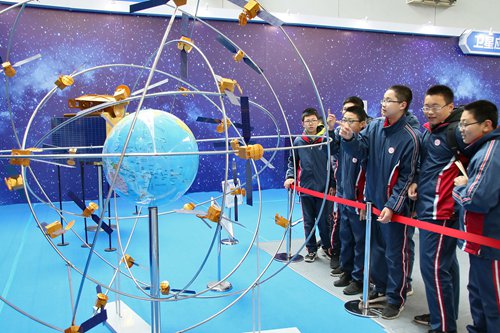
China’s GPS System: An Overview of BeiDou
When people refer to China’s GPS system, they usually mean BeiDou Navigation Satellite System, commonly called BeiDou or BDS. Like GPS, the United States’ Global Positioning System, BeiDou uses satellites to help compatible devices determine their location, speed, and time. It supports navigation in vehicles and phones, as well as services used in transportation, agriculture, surveying, and other industries.
What Is BeiDou?
BeiDou is China’s independently developed global satellite navigation system. Its name comes from the Chinese term for the Big Dipper constellation. The system is operated by China and is part of a broader group of satellite navigation systems that also includes GPS, Europe’s Galileo, and Russia’s GLONASS.
BeiDou’s development took place in stages. Earlier generations provided regional coverage, while the third-generation system, known as BeiDou-3 or BDS-3, began providing global services in 2020. Today, BeiDou can serve users around the world, although the availability and performance of its services can vary by location, device, and surrounding conditions.
How the System Works
BeiDou satellites transmit signals containing information about their position and the time the signal was sent. A receiver—such as a smartphone, vehicle navigation unit, or surveying instrument—uses signals from multiple satellites to calculate its position. In general, signals from more satellites can help a receiver determine its location more reliably, especially when some signals are blocked.
Like other satellite navigation systems, BeiDou does not require a user to send their location to the satellites to receive basic positioning signals. However, a device may use mobile data, Wi-Fi, or other services alongside satellite signals to improve location estimates or provide maps, traffic updates, and search results.
Key Features and Uses
- Global positioning and timing: BeiDou provides positioning and timing services for compatible receivers worldwide.
- Regional services: Some BeiDou services are designed to provide additional capabilities in the Asia-Pacific region.
- Short-message communication: BeiDou includes short-message communication capabilities in certain services and compatible equipment. Availability depends on the device, service, and location.
- High-precision applications: Specialized receivers can use BeiDou signals, often together with other satellite systems and correction services, for more precise positioning.
BeiDou is used in smartphones, vehicle navigation, fleet management, shipping, agriculture, construction, disaster response, and infrastructure monitoring. In many applications, it works alongside other satellite systems rather than operating by itself.
BeiDou Compared with GPS
BeiDou and GPS perform similar core functions: both provide satellite-based positioning, navigation, and timing. The main difference is that they are separate systems operated by different countries. A receiver designed to use multiple systems can often access signals from BeiDou, GPS, Galileo, and GLONASS, depending on its hardware and software.
Using multiple systems can improve the number of available satellites and may help a device maintain a position fix in challenging environments, such as urban areas with tall buildings. It does not guarantee perfect accuracy. Buildings, mountains, trees, interference, receiver quality, and atmospheric conditions can all affect results.
Does a Phone Use BeiDou?
Many modern smartphones and navigation devices support more than one satellite navigation system. Whether a particular device can use BeiDou depends on its chipset, regional model, software, and settings. Support for a satellite system also does not necessarily mean that every app will use it in the same way; apps may combine satellite positioning with Wi-Fi, cellular networks, and other location sources.
To check compatibility, review the device manufacturer’s specifications or technical documentation. A satellite-navigation app or diagnostic tool may also show which systems the device can receive, though the information displayed varies by product.
Why BeiDou Matters
BeiDou gives China an independent satellite navigation capability and contributes another global option for positioning and timing. For users, its broader significance is often practical: compatible devices can combine BeiDou signals with other navigation systems to support everyday directions and specialized operations.
As satellite navigation continues to evolve, BeiDou is likely to remain an important part of the worldwide positioning ecosystem. Its performance for any individual user will depend on the receiver, the environment, and the services available in that area.
8 Advantages of the Chinese GPS System: Global Coverage, Versatility, and Enhanced Precision
- Provides global positioning coverage.
- Offers an alternative to GPS.
- Can work alongside other satellite systems.
- Supports navigation and timing services.
- Used in phones, vehicles, and ships.
- Helps support precision agriculture.
- Enables specialized high-precision applications.
- Adds resilience through multiple navigation options.
Challenges of Using the Chinese GPS System: Device Compatibility, Signal Strength, Equipment Needs, and Regional Limitations
- Device support can vary by model and region.
- Tall buildings and indoor spaces can weaken signals.
- High-precision services may require specialized equipment.
- Some BeiDou features are limited to specific regions or devices.
Provides global positioning coverage.
China’s BeiDou Navigation Satellite System (BDS) provides global positioning coverage, allowing compatible devices around the world to determine their location, speed, and time. This broad reach supports uses ranging from everyday navigation to transportation, agriculture, and infrastructure services. In many devices, BeiDou can also work alongside GPS and other satellite systems, giving receivers more signals to use when calculating a position.
Offers an alternative to GPS.
BeiDou, China’s satellite navigation system, offers an alternative to GPS and adds another independent source of positioning, navigation, and timing signals. This gives users and service providers more options, while compatible devices can combine BeiDou with GPS and other satellite systems to improve signal availability and reliability—particularly in places where buildings or terrain obstruct some satellites.
Can work alongside other satellite systems.
One advantage of China’s BeiDou navigation system is that it can work alongside other satellite systems, including GPS, Galileo, and GLONASS. Compatible devices can use signals from multiple systems to access more satellites, which may help improve positioning availability and reliability—especially in areas where buildings, terrain, or other obstacles block some signals.
Supports navigation and timing services.
One key advantage of China’s BeiDou Navigation Satellite System is that it supports both navigation and timing services. Compatible devices can use satellite signals to determine location and help users find their way, while precise timing helps synchronize systems used in telecommunications, transportation, power networks, and other industries. These capabilities make BeiDou useful for everyday navigation as well as services that depend on accurate positioning and time.
Used in phones, vehicles, and ships.
One key advantage of China’s BeiDou navigation system is its versatility: it can be used in smartphones, vehicles, and ships. On phones, BeiDou can help provide location and navigation services; in vehicles, it can support route guidance and fleet tracking; and at sea, it can assist ships with positioning and navigation. Its use across different kinds of devices and transportation helps make satellite navigation useful in everyday life and a wide range of industries.
Helps support precision agriculture.
BeiDou, China’s satellite navigation system, helps support precision agriculture by providing location and timing data that farmers can use to guide equipment, map fields, and monitor operations. When paired with compatible machinery and farm-management tools, satellite guidance can help with planting, irrigation, and fertilizer application, reducing overlap and improving efficiency. Its effectiveness depends on the equipment, signal conditions, and correction services available.
Enables specialized high-precision applications.
BeiDou, China’s satellite navigation system, can support specialized high-precision applications such as surveying, construction, precision agriculture, and infrastructure monitoring. When paired with compatible receivers and correction services, its signals can help professionals determine positions with greater accuracy than standard navigation alone, supporting tasks that require precise measurements and dependable location data.
Adds resilience through multiple navigation options.
One key advantage of China’s BeiDou navigation system is that it adds resilience by giving compatible devices another positioning option alongside GPS, Galileo, and GLONASS. When a receiver can access signals from multiple systems, it may have more satellites available to calculate its location, helping it maintain navigation in challenging conditions such as dense urban areas or partial signal blockages. This added redundancy can make navigation services more dependable, though actual performance depends on the device, signal conditions, and location.
Device support can vary by model and region.
One drawback of China’s BeiDou navigation system is that device support can vary by model and region. Even if a manufacturer advertises BeiDou compatibility, a particular phone or GPS unit may not support it in every market, or its software may use the system differently. Check the device’s specifications for your exact model and region before relying on BeiDou features.
Tall buildings and indoor spaces can weaken signals.
Tall buildings and indoor spaces can weaken BeiDou signals because satellite transmissions may be blocked, reflected, or scattered by concrete, metal, and glass. As a result, a compatible device may take longer to find your location or show less accurate positioning in dense city centers, garages, and buildings. Using BeiDou together with other satellite systems or location sources, such as Wi-Fi and cellular networks, may help, but performance can still vary.
High-precision services may require specialized equipment.
One drawback of China’s BeiDou navigation system is that its high-precision services may require specialized equipment. While standard smartphones and navigation devices can provide general location information, applications that need centimeter-level accuracy—such as surveying, precision agriculture, or construction—often rely on advanced receivers, correction data, and technical setup. These added requirements can increase costs and make the services less practical for casual users.
Some BeiDou features are limited to specific regions or devices.
One drawback of China’s BeiDou navigation system is that some features are available only in certain regions or on compatible devices. This means users may not be able to access the same services everywhere, and older phones, vehicle navigation units, or other receivers may not support them at all. Before relying on a particular BeiDou feature, check whether it is supported by both your device and the service area.