LORAN Navigation: How It Worked and Why It Still Matters
LORAN, short for Long Range Navigation, is a terrestrial radio navigation system developed to help ships and aircraft determine their position. For much of the 20th century, it provided an important alternative to visual navigation and later satellite-based systems such as GPS. Although traditional LORAN service has ended in many places, the technology remains relevant in discussions about backup navigation and resilient positioning.
How LORAN Works
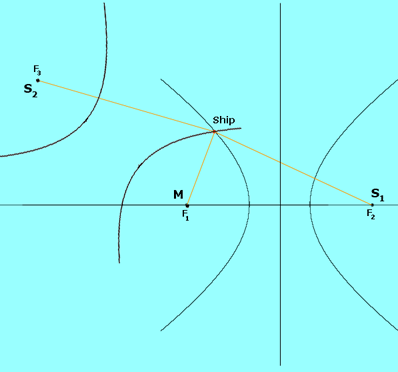
LORAN determines location by measuring the difference in arrival times between radio signals transmitted from several fixed stations. A group of coordinated stations is called a chain. One station acts as the master, while the others transmit as secondary stations, sometimes called slaves.
Because radio signals travel at a known speed, the difference in the time it takes signals from two stations to reach a receiver corresponds to a difference in distance. Each measured time difference identifies a curved line of possible positions, known as a line of position. A receiver uses measurements from multiple station pairs to find where those lines intersect and estimate the user’s location.
LORAN is therefore a hyperbolic navigation system: it does not depend on measuring the receiver’s distance from a single transmitter. Instead, it uses differences in distance from pairs of transmitters.
From LORAN-A to LORAN-C
Several versions of the system were developed. LORAN-A was used during and after World War II. LORAN-C later became the best-known long-range version and was widely used by maritime navigators. Its low-frequency signals could travel long distances, especially over water, making it useful far beyond the reach of many land-based visual aids.
LORAN receivers evolved over time. Early systems often required operators to read signal displays and plot position manually on specialized charts. Later receivers automated much of the timing and calculation, presenting a latitude and longitude or a position directly to the user.
Uses of LORAN Navigation
LORAN was used primarily for marine navigation, including coastal and offshore travel. It also supported some aviation and land-based applications. Its long range and shore-based transmitters made it valuable in areas where other navigation aids were limited.
Unlike a satellite navigation receiver, a LORAN receiver did not need a clear view of the sky. It received signals from ground-based stations, which could be an advantage in certain conditions. However, the system depended on the availability and geometry of its transmitting chain, as well as the quality of the received signals.
Accuracy and Limitations
LORAN accuracy varied with location, receiver quality, station configuration, and environmental conditions. Signal propagation over land and water can differ, and factors such as terrain, coastal conditions, and electrical interference can affect timing measurements. Users also needed appropriate charts or receiver data to interpret the position correctly.
Like other radio navigation systems, LORAN could be affected by interference or signal disruption. Its coverage depended on operating transmitters, so it was not a universal service. It also required dedicated infrastructure on the ground, whereas GPS relies on satellites orbiting Earth.
LORAN and GPS
GPS made global positioning easier and more widely available, but satellite signals can be vulnerable to jamming, interference, and blockage. LORAN’s terrestrial signals offered a different way to determine position and could potentially serve as a complementary or backup source where a suitable network was operating.
Modernized versions, often referred to as eLORAN, were designed to improve timing and navigation performance using updated transmitters and digital techniques. Interest in eLORAN has been tied to the need for resilient alternatives or supplements to satellite-based positioning, navigation, and timing. Availability and operational status vary by country and region, so users should verify local service information rather than assume coverage.
Is LORAN Still in Use?
Traditional LORAN-C service has been discontinued in many parts of the world. In the United States, the federal government terminated the LORAN-C system in 2010. Some countries have explored or operated modernized eLORAN services, but there is no single worldwide LORAN network available to all users today.
For anyone considering LORAN or eLORAN equipment, it is important to confirm that transmitters are active in the intended operating area and that the receiver supports the relevant system. Historical charts and legacy receivers may not reflect current service conditions.
A Lasting Contribution to Navigation
LORAN helped generations of mariners and other travelers navigate over long distances before satellite positioning became commonplace. Its use of synchronized terrestrial transmitters introduced a practical way to calculate position from radio timing differences. Today, its legacy continues in the search for dependable navigation systems that can complement GPS and provide resilience when satellite services are unavailable.
Exploring LORAN Navigation: Current Use, System Overview, and Future Prospects
- Is LORAN navigation still in use?
- What is LORAN navigation system?
- What is LORAN in navigation?
- Is LORAN coming back?
- Do boats still use LORAN?
- Is LORAN obsolete?
Is LORAN navigation still in use?
LORAN navigation is no longer widely used, and traditional LORAN-C service has been discontinued in many countries, including the United States, where it ended in 2010. Some regions have explored or operate modernized eLORAN systems as a backup or complement to GPS, but coverage is limited and varies by location. Check local service availability and receiver compatibility before relying on LORAN or eLORAN for navigation.
What is LORAN navigation system?
The LORAN (Long Range Navigation) system is a radio-based navigation technology that helps determine a receiver’s location by comparing the arrival times of signals from multiple fixed ground stations. By measuring the differences in signal timing, a LORAN receiver calculates intersecting lines of position to estimate where it is. LORAN was widely used for marine navigation and other applications before satellite systems such as GPS became common; traditional service has since been discontinued in many regions, though modernized eLORAN systems may be available in some areas.
What is LORAN in navigation?
LORAN, short for Long Range Navigation, is a radio-based navigation system that helps determine a receiver’s position by comparing the arrival times of signals from multiple ground-based transmitters. The time differences are used to calculate lines of position, which intersect to indicate the receiver’s location. LORAN was widely used for maritime navigation before GPS became common, though traditional service has been discontinued in many regions. Availability of modernized systems, such as eLORAN, varies by location.
Is LORAN coming back?
LORAN is not returning as a single worldwide navigation service, but modernized versions known as eLORAN have been considered or developed in some regions as a backup to GPS. Whether it is available depends on local government plans, operating transmitters, and compatible equipment. Check current information from your country’s navigation or transportation authorities before relying on LORAN or eLORAN for navigation.
Do boats still use LORAN?
Most boats no longer use traditional LORAN for navigation because LORAN-C service has been discontinued in many countries, including the United States. Today, mariners generally rely on GPS and other electronic or traditional navigation methods. Some regions have explored modernized eLORAN as a complementary or backup system, but availability is limited and varies by location. Check local service coverage and equipment requirements before relying on it.
Is LORAN obsolete?
Traditional LORAN is largely obsolete as a day-to-day navigation service: many stations have been shut down, and the United States ended its LORAN-C service in 2010. However, the underlying technology is still relevant. Modernized eLORAN has been developed as a possible backup or complement to GPS, particularly when satellite signals are disrupted. Availability varies by country and region, so check for active local service before relying on LORAN or eLORAN for navigation.