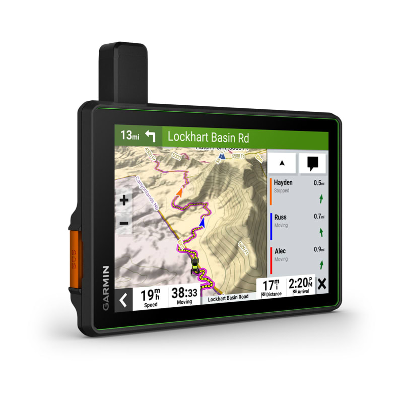
Garmin Off-Road GPS: A Guide to Choosing the Right Navigator
Off-road travel can take you far beyond cell service and familiar roads. A dedicated GPS navigator can help you follow trails, understand the terrain, and find your way back when a route becomes difficult. Garmin offers several devices designed for outdoor navigation, including handheld GPS units and rugged navigators made for vehicles such as ATVs, motorcycles, and side-by-sides.
What Is a Garmin Off-Road GPS?
A Garmin off-road GPS is a navigation device intended for use on trails and other routes that may not appear on standard road maps. Depending on the model, it may provide topographic maps, trail information, a compass, elevation data, route recording, and navigation that works without a cellular connection.
Garmin’s off-road options vary considerably. Some are compact handheld devices suited to hiking and exploring on foot. Others have larger touchscreens, vehicle mounts, and controls designed for use on an ATV, motorcycle, or other off-road vehicle. Features and map coverage differ by model, so it is important to check the specifications before buying.
Key Features to Consider
Maps and Trail Coverage
Map availability is one of the most important factors. Some devices include preloaded topographic or road maps, while others support additional maps or require a separate purchase. Check whether maps cover the area where you plan to ride, hike, or camp, and review how updates are provided.
Trail data can also vary by region and source. A GPS device may help you navigate mapped routes, but it cannot guarantee that a trail is open, passable, or legal to use. Confirm local access rules and current conditions before setting out.
Ruggedness and Weather Resistance
Off-road equipment may face dust, rain, vibration, mud, and impacts. Look for a device designed for outdoor use, and review its stated water-resistance and operating limits. A rugged device is not indestructible, so secure mounting and sensible handling still matter.
Screen Size and Controls
A larger screen can make maps easier to read from a vehicle, while a smaller handheld unit may be more convenient to carry. Touchscreens are straightforward to use, but physical buttons can be useful in wet conditions or when wearing gloves. Think about where the GPS will be mounted and how easily you can view and operate it safely.
Battery Life and Power
Battery life depends on the model, screen brightness, satellite settings, and other features in use. Handheld units may run on replaceable or rechargeable batteries, while vehicle-focused models may be designed to connect to the vehicle’s power system. For long trips, consider carrying a backup power source and checking the device’s expected runtime.
Satellite Navigation and Offline Use
A GPS receiver can determine your position using satellite signals without mobile data. That makes a dedicated navigator valuable in areas with little or no cell coverage. However, maps and route information generally need to be available on the device in advance. Download or install the maps you need before leaving service, and test the setup at home.
Handheld GPS or Vehicle-Mounted Navigator?
A handheld Garmin GPS may be a good fit for hiking, camping, geocaching, or exploring on foot. These devices are typically portable and can be carried in a pack or pocket, though their screens are often smaller than those of vehicle-oriented units.
A vehicle-mounted navigator may be more convenient for ATV, motorcycle, or side-by-side use. Larger screens and dedicated mounts can make route viewing easier, and some models offer features tailored to motorized recreation. Before choosing one, check that the device and mount are compatible with your vehicle and intended riding conditions.
Planning a Safer Off-Road Trip
A GPS is a useful navigation aid, but it should not be your only preparation. Before heading out:
- Check trail closures, access permissions, and local regulations.
- Load the right maps and save important locations, such as your starting point and camp.
- Bring a paper map or another backup navigation method.
- Tell someone your route and expected return time.
- Carry water, appropriate clothing, and emergency supplies.
- Keep your attention on the trail rather than the screen while moving.
How to Choose the Best Garmin Off-Road GPS
Start by deciding how you will use the device. A hiker may prioritize portability, battery options, and handheld controls. Someone riding an ATV may prefer a larger display, a secure vehicle mount, and a power connection. Then compare map coverage, screen visibility, durability, battery performance, and the cost of any additional maps or accessories.
Garmin’s product lineup changes over time, and features can differ even among devices designed for similar activities. Review the current product specifications and confirm that a model supports the maps and accessories you need before purchasing.
Final Thoughts
A Garmin off-road GPS can make it easier to navigate trails and stay oriented beyond cell coverage. The right choice depends on your activity, vehicle, preferred screen size, and map requirements. With the appropriate device, up-to-date maps, and sound trip planning, you can use GPS as a helpful part of a safer and more confident outdoor adventure.
Essential Tips for Using Garmin Off-Road GPS: Stay Prepared and Navigated
- Download maps before leaving cell coverage.
- Load tracks and waypoints ahead of time.
- Carry spare batteries or a power bank.
- Mount the GPS where it’s easy to see.
- Use topo maps for rugged terrain.
- Record your track to retrace your route.
- Enable trip alerts for key waypoints.
- Keep a paper map as a backup.
- Check GPS signal before starting out.
Download maps before leaving cell coverage.
Download the maps you need before leaving cell coverage. Many off-road areas have limited or no mobile service, so loading maps ahead of time helps ensure you can view trails and navigate even when your phone can’t connect to the internet. Check that the maps cover your route, save any important locations, and confirm they’re available offline before you head out.
Load tracks and waypoints ahead of time.
Load tracks and waypoints onto your Garmin off-road GPS before you leave. Save your planned route, trail junctions, campsites, water sources, and other important locations while you have reliable access to a computer or phone. Then confirm the data appears correctly on the device and that the needed maps are available offline. Preparing in advance makes it easier to stay on course when cell service is unavailable—and helps you avoid fumbling with route setup on the trail.
Carry spare batteries or a power bank.
Carry spare batteries or a fully charged power bank when using a Garmin off-road GPS, especially on long trips or in remote areas. GPS use, bright screens, and cold weather can drain power faster than expected, so a backup helps keep your maps and navigation available throughout the journey. Check your device’s battery type and charging requirements before you go, and store backups somewhere dry and easy to reach.
Mount the GPS where it’s easy to see.
Mount your Garmin off-road GPS where you can glance at it easily without taking your attention off the trail. Choose a secure position that stays within your natural line of sight, avoids blocking your view, and keeps the screen clear of glare when possible. Before riding, adjust the mount and route settings while stopped, and make sure the device won’t interfere with vehicle controls or become loose on rough terrain.
Use topo maps for rugged terrain.
Use topographic maps when navigating rugged terrain with a Garmin off-road GPS. Topo maps show elevation changes, contours, ridgelines, valleys, and other landscape features that standard road maps may not include, helping you better understand what lies ahead and choose a suitable route. Download the maps for your destination before leaving, since remote areas may have little or no cell service, and remember that map details can vary by region.
Record your track to retrace your route.
Record your track before heading off-road so you can retrace your route if a trail becomes confusing or you need to return to your starting point. Most Garmin GPS devices can save a track as you travel, marking the path you’ve taken even when cell service is unavailable. Before setting out, confirm track recording is enabled and that your device has enough battery and storage. When it’s time to head back, follow the saved track carefully and stay alert to changing trail conditions.
Enable trip alerts for key waypoints.
Enable trip alerts for key waypoints on your Garmin off-road GPS to get timely reminders as you approach important locations, such as trail junctions, campgrounds, water stops, or your planned turnaround point. Set alerts before you leave, confirm each waypoint is placed correctly, and choose notification settings that are easy to notice without distracting you. Use alerts as a helpful prompt—not a substitute for watching the trail or checking your map.
Keep a paper map as a backup.
Always carry a paper map as a backup when using a Garmin off-road GPS. Batteries can run low, devices can be damaged, and satellite signals may be harder to receive in some terrain. A map of the area, together with a compass and basic navigation skills, can help you stay oriented if your GPS is unavailable. Before your trip, mark your route, trail junctions, and key landmarks so the map is easy to use when you need it.
Check GPS signal before starting out.
Before heading out, check that your Garmin off-road GPS has acquired a reliable satellite signal while you’re still in an open area. Trees, steep terrain, buildings, and vehicle shelters can delay or weaken reception. Confirm that the device shows your current location and is ready to navigate, then save your starting point if the model supports it. Taking a moment to check the signal before you ride or hike can help prevent confusion once you’re farther from familiar routes.