Garmin GPSMAP 65s: A Rugged Handheld GPS for Outdoor Navigation
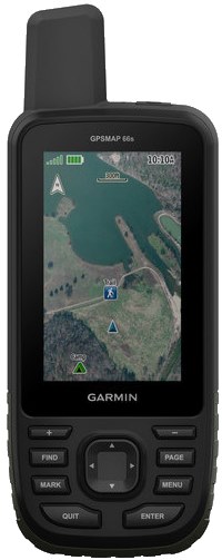
The Garmin GPSMAP 65s is a handheld GPS navigator designed for hiking, backpacking, hunting, and other outdoor activities where dependable positioning matters. It combines multi-band satellite reception with mapping features and built-in sensors, giving users several ways to navigate when they’re away from cellular coverage.
More Reliable Positioning in Challenging Terrain
A key feature of the GPSMAP 65s is its support for multi-band GNSS. It can use compatible satellite systems and multiple frequencies to help improve location accuracy, particularly in places where signals may be obstructed or reflected, such as forests, narrow valleys, and areas with tall buildings. Actual performance varies with terrain, weather, satellite availability, and device settings, but the added reception capability can be useful on demanding routes.
Mapping and Route Planning
The device is built around a 2.6-inch color display and a button-based interface that can be operated without relying on a touchscreen. Depending on the model and region, it may include preloaded topographic mapping. Users can also add compatible maps and manage routes, tracks, and waypoints for trip planning and navigation.
For more detailed planning, the GPSMAP 65s can work with Garmin’s compatible software and services. With a suitable connection, users can organize trip data and transfer information between the handheld and other devices. Before heading out, it’s wise to confirm that the maps cover the intended area and to download or prepare any needed data in advance.
Compass and Altimeter Sensors
The “s” in GPSMAP 65s distinguishes it from the GPSMAP 65: the 65s includes a 3-axis electronic compass and a barometric altimeter. The compass can provide directional information while stationary, while the altimeter uses barometric readings to help track elevation changes. These sensors can add useful context to a route, though barometric altimeter readings may need calibration and can be affected by changing weather conditions.
Designed for Field Use
The GPSMAP 65s uses physical buttons, which can be practical in wet conditions or when wearing gloves. It runs on two AA batteries, making it possible to carry spares and replace power in the field. Battery life depends on battery type, settings, temperature, and satellite usage, so carrying extra batteries is a sensible precaution on longer trips.
Who Is the GPSMAP 65s For?
The GPSMAP 65s may suit outdoor users who want a dedicated navigation device with advanced satellite reception, physical controls, and onboard sensors. It can be especially appealing to hikers and backcountry travelers who prefer a handheld unit over relying solely on a phone. The screen is relatively compact, however, and users who prioritize a large display or touchscreen may prefer a different device.
What to Consider Before Buying
- Map coverage: Check which maps are included for your region and whether additional maps are needed.
- Power: Plan for AA battery replacements, especially on multi-day trips.
- Learning curve: Button-operated GPS units can take time to learn; practice with routes and settings before relying on the device outdoors.
- Navigation backup: Carry a paper map and compass, and know how to use them. A GPS is a helpful tool, not a substitute for preparation.
- Model details: Features, bundled maps, and availability can vary by region or package, so check the exact product listing before purchasing.
Conclusion
The Garmin GPSMAP 65s is a capable handheld navigator for people who venture beyond reliable cellular coverage. Its multi-band GNSS support, compass, barometric altimeter, and replaceable AA batteries make it a practical option for serious outdoor use. With suitable maps and a little practice, it can help users plan routes, monitor their position, and stay oriented in the field.
7 Essential Garmin GPSMAP 65s Tips for Accurate Navigation and Longer Battery Life
- Use multi-band GNSS in challenging terrain for improved positioning.
- Carry spare AA batteries for longer trips.
- Calibrate the compass after changing locations or batteries.
- Calibrate the barometric altimeter for more accurate elevation readings.
- Save important locations as waypoints before heading out.
- Record a track so you can retrace your route.
- Adjust the backlight timeout to help conserve battery.
Use multi-band GNSS in challenging terrain for improved positioning.
When navigating through challenging terrain such as dense forests, deep valleys, or areas with tall buildings, enable multi-band GNSS on the Garmin GPSMAP 65s for more reliable positioning. By receiving signals on multiple frequencies from compatible satellite systems, the device can better handle some obstructions and signal reflections. Reception still depends on conditions, so keep the unit positioned with a clear view of the sky whenever possible and carry a map and compass as backup.
Carry spare AA batteries for longer trips.
For longer trips, carry a spare set of AA batteries for your Garmin GPSMAP 65s. GPS use, cold weather, and certain settings can drain power faster, so extra batteries help keep the device ready when you need it. Store them securely in a dry place, and check that they’re compatible with the unit before heading out.
Calibrate the compass after changing locations or batteries.
Calibrate the Garmin GPSMAP 65s compass after changing locations or replacing the batteries to help maintain accurate direction readings. Nearby magnetic interference and changes in the device’s environment can affect the compass, so follow the on-screen calibration steps and rotate the unit as instructed. For best results, calibrate outdoors, away from vehicles, metal objects, and other potential sources of interference.
Calibrate the barometric altimeter for more accurate elevation readings.
Calibrate the Garmin GPSMAP 65s barometric altimeter before your trip for more accurate elevation readings. Set it using a known elevation from a reliable map or a location where the elevation is posted, or use a known barometric pressure if available. Because changes in weather can affect pressure-based readings, recalibrate as conditions shift or when you reach a location with a confirmed elevation.
Save important locations as waypoints before heading out.
Before heading out with your Garmin GPSMAP 65s, save important locations as waypoints, such as your trailhead, campsite, water sources, junctions, or parked vehicle. Marking these spots in advance makes them easier to find during your trip and can help you retrace your route if conditions change. Give each waypoint a clear name, check that it appears in the right location, and bring a map and compass as backup.
Record a track so you can retrace your route.
Record a track on your Garmin GPSMAP 65s to save the path you’ve traveled and make it easier to retrace your route. Before setting out, check that track recording is enabled and that the device has a clear satellite signal. As you hike, the GPSMAP 65s logs your movement, creating a route you can follow back if needed. For added safety, save important locations—such as your trailhead or campsite—as waypoints, and carry a map and compass as backup.
Adjust the backlight timeout to help conserve battery.
Adjusting the backlight timeout on the Garmin GPSMAP 65s can help extend battery life, especially on long hikes or trips away from a power source. Set the screen to turn off after a shorter period of inactivity, then press a button whenever you need to check your map or route. Choose a timeout that keeps the display convenient to use without leaving the backlight on longer than necessary.